
California’s Sierra Buried By Over 100 Inches of Snow
California will wrap up 2021 more mountain snow and valley rain that will continue to challenge holiday travel through New Year’s Eve according to Weather.com
Snow measured in hundred of inches has buried the Sierra Nevada mountains of California and Nevada, as well as some coastal ranges of Northern California.
Several Sierra locations have picked up over 100 inches of snow since Christmas week, including Northstar (134 inches) and Diamond Peak (117 inches). Homewood Mountain, on the western shore of Lake Tahoe, picked up 3 feet of snow in 24 hours through Monday morning, according to the National Weather Service.
The Central Sierra Snow Laboratory set a new December record with 210 inches of snow through Wednesday morning. This is the most extreme December snowfall on record in California, topping a 185-inch December snowfall near Donner Pass in December 1889, according to weather historian Christopher Burt.
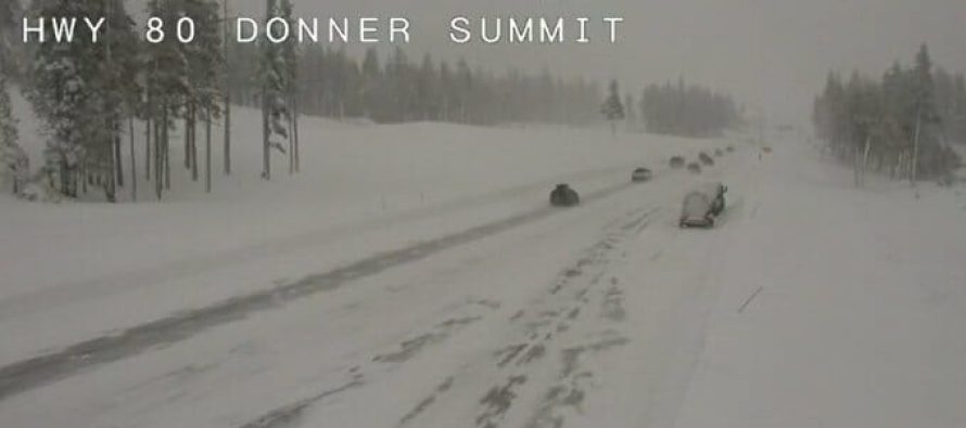
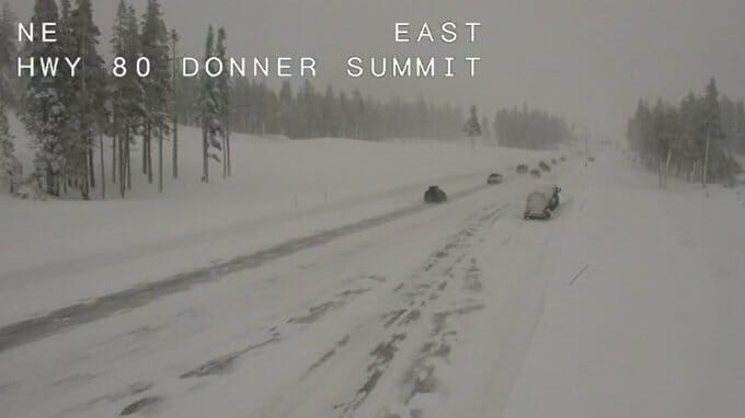
This combination of prolific snow and strong winds crippled travel over the Sierra. Interstate 80 was finally cleared and opened Wednesday. Not only feet of snow, but also numerous downed trees have challenged Caltrans road crews.
Forecast Timeline
Northern California rain and Northern Sierra snow will gradually end Wednesday night.
Southern California rain and snow in the Southern Sierra, and Southland mountains will continue into Thursday before wrapping up Thursday night.

Additional Rain, Snow Forecast
Additional accumulations in the Northern Sierra should be generally less than 6 inches as snow finally winds down. However, a foot or so of additional snow is possible in the Southern Sierra.
While this additional snowfall will be nowhere near the magnitude of what has already fallen, it could still aggravate travel headaches in the Sierra.
Heavy snow accumulations can be expected in the high country of Southern California, at elevations above 5,000 feet into Thursday. Some light snow accumulation is possible down to pass levels in Southern California that could lead to slippery travel.
Check your local road reports before you leave. Pack a winter emergency kit and chains in your vehicle if you must drive in the high country. Let someone else know your travel plans in case you become stranded.

Most of Southern California should pick up another inch or so of rain through early Friday, primarily through Thursday afternoon.
There will still be a threat for local flash flooding in the most flood-prone areas, as well as debris flows off areas recently burned by wildfires.
If you live near an area recently burned by wildfires, monitor the latest developments and heed any evacuation notices from local emergency managers immediately.
Related Articles

Coachella Valley Weather Forecast brought to you by Hot Purple Energy for March 8th
#cvwx Coachella Valley Weather Forecast brought to you by Hot Purple Energy for March 8th – mostly sunny with evening clouds
Coachella Valley / Palm Springs Weather May 18th 2016
#cvwx Coachella Valley Weather May 18th 2016 Day: 99F – Brilliant Sunshine Night: 71F Perfect 20% Chance a little precipitation may occur including
#SNOWING – It’s snowing, not typical for the end of May, Palm Springs Aerial Tramway
#SNOWING It’s snowing!!!! ❄️ ❄️ ❄️ This weather is not typical for the end of May! We don’t think it will
