
Cranston Fire Update, Arson, 89% contained, 13,139 acres burned, 889 Personel
Cranston Fire
#CranstonFire #Update 12:00p August 1st.
89% contained, 13,139 acres burned, 889 Personel
#CranstonFire #Update 12:00p July 30th
About 560 people in Mountain Center and the surrounding area were still evacuated.
A total of 12 buildings were destroyed and five others were damaged in the fire, which began about noon Wednesday as the result of arson, according to authorities.
The brush fire acreage was decreased to 13,139 acres Monday morning as fire crews focused on mopping up and securing the fire’s edge.
#CranstonFire #Update 12:00a July 30th
Cranston Fire Update 57% contained, 13130 acres burned, 1546 fire personel, arson
The evacuation order is lifted for Idyllwild and Pine Cove north of Lower Saunders Meadow Road. Access can be made from Banning on Highway 243. Garner Valley south of Morris Ranch Road. Road access is available from Highway 74 and Highway 371 at Paradise Corner.
Evacuation orders remain in effect for Mountain Center and the surrounding area. Use caution returning home. Residents returning home from the Cranston Fire, losing power means your perishable food is not safe. Don’t risk your family’s health, throw it out!
#CranstonFire #Update 12:00p July 29th
Arson, 29% contained, 13,130 acres burned, 1742 Personel!!!
#CranstonFire #Update 6:42p July 28th
29% contained Gaining a little ground.
DETAILS:
7000 evacuated, 2 firefighter injuries, almost 5,000 structures threatened.
RESOURCES:
Engines: 194 Water Tenders: 5 Helicopters: 9 Fixed-wing: 3 Crews: 17 Dozers: 14 Total Personnel: 1,319
Evacuation Order Lifted for Portions of Garner Valley
The evacuation order is lifted for Garner Valley, south of Morris Ranch Rd. Proof of residency required. Road access is available from Highway 74 at Highway 371.
All other evacuation orders remain in effect. Use caution returning home.
Cranston Fire Update July 28th AM
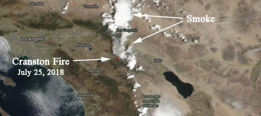
Location of Origin: East of Cranston Fire Station
Start date: July 25, 2018, 11:41 am
Size: Approximately 13,118 acres
Percent Contained: 17 percent
Cause: Human-caused (arson)
Resources Assigned: 1,319 personnel
Cranston Fire Update July 27th
Unit Information
San Bernardino National Forest
U.S. Forest Service
602 South Tippecanoe Ave.
San Bernardino, CA 92408

Highlighted Activity
07/27/2018Cranston Fire Closure Area announced
Closure – 07/27/2018
Incident Overview

Cranston Fire Update 7/27/2018 – 7:30 pm
Location of Origin: East of Cranston Fire Station
Start date: July 25, 2018, 11:41 am
Size: Approximately 12,300 acres
Percent Contained: 16 percent
Cause: Human-caused (arson)
Resources Assigned: 1,319 personnel
Fire Information number: 909-383-5688
Media Contact Line: 909-383-5501
Evacuation Warning
- Paradise Corner
Evacuations
The Riverside Sheriff’s station (951-791-3400) is conducting evacuations of these areas:
- Apple Canyon Area
- Cedar Glen
- Camp Scherman Girlscout Camp
- Fern Valley
- Garner Valley
- Hurkey Creek Area
- Idyllwild
- Lake Hemet Area
- Mountain Center Community
- Mt San Jacinto State Park
- Pine Cove
A evacuation center has been setup at Banning High School (100 W. Westward Ave. Banning, CA) and Hamilton High School (57430 Mitchell Rd. Anza, CA)
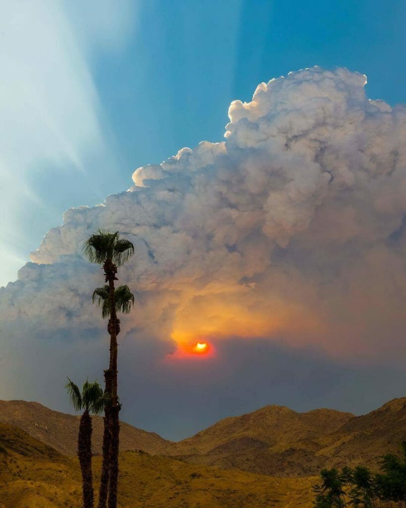
Coachella Valley Cover Photo! So sad to see our mountains in smoke ? – by Steven Young
Road Closures
- HWY 74 from the City of Hemet to HWY 371 at Paradise Corner
- HWY 243 from Banning to intersection of HWY 243 and HWY 74
Recreation Closures
Mt. San Jacinto State Park
- Desert View Trail
- Little Round Valley Campground
- Long Valley Trail
- Mountain Station
- Palm Springs Aerial Tramway
- Round Valley Campground
- Round Valley Trail
- San Jacinto Peak Trail
- Strawberry Junction Campground
- Tamarack Valley Campground
- Wellmans Divide Trail
San Bernardino National Forest San Jacinto Ranger District including the Forest Service lands within the Santa Rosa-San Jacinto Mountains National Monument. The following recreation sites are closed:
- Black Mountain Group Campground
- Boulder Basin Campground
- Cedar Springs Trail 4EI7
- Dark Canyon Campground
- Deer Springs Campground
- Deer Springs Trail to Suicide Rock 3E17 to 3E33
- Devil’s Slide Trail
- Ernie Maxwell Scenic Trail 3E07
- Fern Basin Campground
- Fobes Trail 4E04
- Fuller Ridge
- Humber Park
- Hurkey Creek Campground
- Lake Fulmor Day Use Area
- Lake Hemet Picnic Area
- Little Round Valley Campground
- Marion Mountain Campground
- Pacific Crest Trail (PCT) N of State Highway 74
- San Jacinto Wilderness
- Seven Pines Trail 2E13
- Skunk Cabbage Trail 3E42
- South Ridge Trail 3E08
- Spitler Peak Trail 3E22
- Stone Creek Yellow Post Sites
- Strawberry Creek
- Tahquitz Peak Fire Lookout

Animal Shelters
Residents can call 951-358-7329 for direct assistance with moving animals.
- Large animals can be dropped off to Dysart Equestrian Park – 2101 W Victory Ave in Banning.
- Small Animals can also be dropped off at Dysart Equestrian Park – 2101 W. Victory Ave. in Banning. Animal Services will transfer them to the San Jacinto Valley Animal Campus.
- San Jacinto Valley Animal Campus at 581 S. Grand in San Jacinto is accepting all animals, both domestic and large animals.
- All animals (large and small) also accepted at San Jacinto Valley Animal Campus.
- Coachella Valley Animal Campus located at 72050 Pet Land Place in Thousand Palms is open for small animals only.
Air Quality
The South Coast Air Quality Management District has issued a smoke advisory for the Cranston Fire.
Temporary Flight Restrictions (TFR)
Important Links
Incident Information
| Current as of | 7/27/2018, 6:48:10 PM |
| Incident Type | Wildfire |
| Cause | Human-caused |
| Date of Origin | Wednesday July 25th, 2018 approx. 11:41 AM |
| Location | Idyllwild, Mountain Center, Highway 243 and Highway 74 |
| Incident Commander | Unified Command |
| Coordinates | 33.72 latitude, -116.8 longitude |
Current Situation
| Total Personnel | 1,319 |
| Size | 12,300 Acres |
| Percent of Perimeter Contained | 16% |
| Fuels Involved | Timber, Brush (2 feet), and Chaparral (6 feet) |
| Significant Events | Active, uphill runs, flanking, backing |
Outlook
| Planned Actions | Prioritize structure defense around mountain communities, utilizing existing fuel breaks and fuels treatment areas, roads and advantageous topographic features. |
| Projected Incident Activity | Continue to protect communities and values at risk. Keep the fire east of the North Fork of the San Jacinto River, south of Idyllwild and within control lines, west of the desert divide, north of the South Fork of the San Jacinto River. |
Current Weather
| Weather Concerns | Continued hot and dry conditions lined up for the weekend, with westerly winds each afternoon and evening. Slight chance of afternoon thunderstorms, increasing chances into early next week with anticipated increases in relativity humidity values. Winds will have a north component overnight. |
Recent Articles
Related Links
Incident Cooperators


Related Articles
Apple Fire is 30% Contained, Riverside County Evacuations Lifted
BANNING, CA – The Apple Fire is now 30 percent contained, the U.S. Forest Service said Wednesday in an update, as
Flashflood Watch in effect till 7pm issued for the Coachella Valley
Flashflood Watch in effect till 7pm. Lightning and Thunder Rolling in and we can hear it here in Studio in

25th anniversary Jazz in the Pines survives Cranston Fire, let the “Music” play on……….
MUSIC Jazz in the Pines will go on as scheduled! Let the music play on!!! Idyllwild Arts was
