Cool off, Hike San Jacinto Peak
by Coachella Valley | September 4, 2019 11:38 am
San Jacinto Peak via Marion Mountain
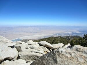
Naturalist John Muir wrote of San Jacinto Peak, “The view from San Jacinto is the most sublime spectacle to be found anywhere on this earth!” Who am I to argue with Muir? At 10,834′ Mt. San Jacinto does indeed reward the determined hiker with wonderful views.
You can see the inland empire, Palm Desert, the San Bernardino and San Gabriel mountains, Mt. Palomar in San Diego, Santiago and Modjeska peaks, and on a really clear day,you might even catch a glimpse of Catalina Island.
 [1]
[1]
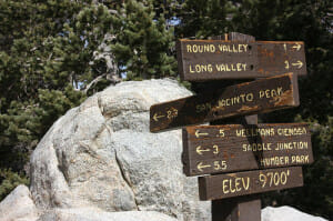
There are several routes up San Jacinto. Most people take the Palm Springs Aerial Tram up from the desert floor and begin their journey in Long Valley. The lesser-travelled Marion Mountain trail skips the tram, beginning a few miles north of Idyllwild. It’s the shortest route up Mt. San Jacinto. It’s also steep, relentlessly climbing over 4,600 feet in just 5.7 miles.
In spite of the rigor, this is a beautiful, rewarding hike.
This is the fifth of six southern California summits in the 6-Pack of Peaks bundle. Done in sequence, they provide great training anyone preparing for bigger hikes such as Mt. Whitney or Half Dome. Each hike in the 6-Pack is progressively higher in altitude, and all have respectable distance and vertical elevation gain.
Tips: Allow sufficient time to get to the trailhead. This place is not freeway-close by any measure. It took us a full two hours to get there from Orange County. Add your driving time to the hiking time, and you’ve pretty nearly filled your day.
Second, if you’re meeting your hiking partners, plan to meet at the Ranger Station in Idyllwild, then caravan to the trailhead outside of town. It’s easy to find the Ranger Station; but not so easy to find the trailhead. [2]
[2]
Permits are required, even for day hikes. You can get one easily however. There are self-service forms to fill out at the ranger station in Idyllwild at 25905 State Highway 243.
A National Forest Adventure Pass must be displayed in your parked car at the trailhead.
Finally, when you’ve finished your hike, stop in Idyllwild for a cold beverage and a well-earned meal at Arriba’s Mexican Restaurant. Great prices and nice outdoor patios.
 [3]
[3]- [Image]: https://coachellavalley.com/wp-content/uploads/2014/08/4151020908_ce27513308.jpg
- [Image]: https://coachellavalley.com/wp-content/uploads/2014/08/Mt-465x348.jpg
- [Image]: https://coachellavalley.com/wp-content/uploads/2014/08/IMG_0176a.jpg
- https://www.everytrail.com/guide/san-jacinto-peak-via-marion-mountain: https://www.everytrail.com/guide/san-jacinto-peak-via-marion-mountain
- by SoCalHikers: https://coachellavalley.com/wp-content/uploads/2014/08/IMG_0176a.jpg
Source URL: https://coachellavalley.com/hike-san-jacinto-peak/